By Joe Allen, director, Gwinnett Place CID | As the Gwinnett Place Community Improvement District completed its Activate Gwinnett Place Multi-Modal Green Corridor Master Plan, the idea was to propose bold ideas for the District’s future.
Building upon the 2012 LCI vision for the area, the Activate Gwinnett Place identifies specific projects for investment to improve transportation options, storm water challenges, connectivity and livability through greenspaces and feasible infrastructure changes.
The master plan identifies an infrastructure framework that invites mixed-use developments, creates greater connectivity between commercial centers and enhances public green space. The plan’s key elements include a “grand promenade” trail network, connectivity with McDaniel Farm Park, intersection and roadway improvements, and storm water management solutions that can also serve as a public amenity.
Any redevelopment done in the area will have to comply with current storm water management codes and practices. The Activate Gwinnett Place plan proposes improving the existing pond to provide more storage of storm water runoff, thereby reducing costs for potential redevelopers. The current footprint could remain the same, but have a deeper pond depth that could expand to neighboring open parcels. It also can be used as a park amenity.
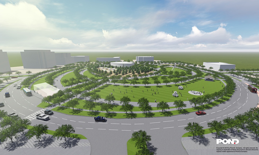
 To move away from an auto-centric area to a pedestrian and bike friendly urban fabric, Activate Gwinnett Place proposes improvements to roadways to make them more pedestrian and bike friendly. In the long-range, possible intersection improvements at Satellite Boulevard and Pleasant Hill Road could provide for enhanced walkability and open space. One possible intersection improvement design might take the form of a circular, signalized roadway or traffic circle.
After all, traffic studies show that an increase of development activity will likely cause the Pleasant Hill Road and Satellite Boulevard intersection to fail. The plan proposes creating a transformative traffic circle at the intersection. Similar traffic circles, such as Young Circle Park in Hollywood, Fla., are in use around the globe. The CID has recently issued a RFP to continue refining this concept.
A large linear park known as the “grand promenade” could serve as “the spine” that connects all the projects and property in the area. This promenade serves as a path for both pedestrians and bicyclists moving throughout the central business district. The width might vary from 15 to 100 feet wide. It would be lined with public spaces that reflect the rich diversity of today’s Gwinnett County.
At the widest segments, social space such as kiosks, cafés, plazas and mini-play areas will co-exist with a multi-use path network designed for both pedestrians and cyclists. The design intent includes a series of multi-cultural gardens and spaces or uses.
The proposed grand promenade also creates a buffer, softening the transition between parking, traffic and commercial or social destinations. The actual alignment will vary, depending on the property owners willingness to take advantage of its access to parcels it fronts. The CID will soon be releasing a RFP to determine potential design standards.
Another project is for greater connectivity to a hidden jewel in the area, McDaniel Farm Park. A bike-and-pedestrian bridge is proposed across Satellite Boulevard to connect McDaniel Farm Park and the Grand Promenade, to take advantage of the existing county park and provide safer access between park spaces. The CID is also continuing to further analyze the potential of a pedestrian and bicycle bridge spanning Satellite Boulevard that will link McDaniel Farm Park and the rest of the commercial area.
The Activate Gwinnett Place Plan, when implemented, will begin the transformation of Gwinnett’s central business district at Gwinnett Place.


Follow Us