
By Elliott Brack
Editor and Publisher, GwinnettForum
AUG. 2, 2019 | Some day, years from now, a few homeowners in Gwinnett are going to be surprised to find a four-lane highway mighty close to the homes that they occupy in 2019. The roadway will be the extension of Sugarloaf Parkway, which planners have already put in motion.
 The current Sugarloaf Parkway extends from Peachtree Industrial Boulevard in Duluth, in a northeasterly semi-circle through the edges of Lawrenceville past I-85, crosses Georgia Highway 316, circling past Five Forks Trickum Road, on past Scenic Highway and Georgia Highway 20 near Grayson to its present end at Georgia Highway 316 near Dacula. But there’s more coming.
A new part of the road, currently known as Phase 2, won’t happen soon. Eventually it will push the four-lane road to Interstate 85 between Gravel Springs Road and Georgia Highway 20. This 6.8 mile extension anticipated completion time of this road will be in about two years. The road will include a four lane divided highway with a raised median, bicycle and pedestrian facilities, turn lanes as well as grade separation at I-85, Georgia Highway 124, Old Fountain Road, Old Peachtree Road, Fence Road, Georgia Highway 8, and Georgia Highway 316.
The new road will add roadway capacity and address peak period congestion in the northern part of the county, which is experiencing rapid population and employment growth.
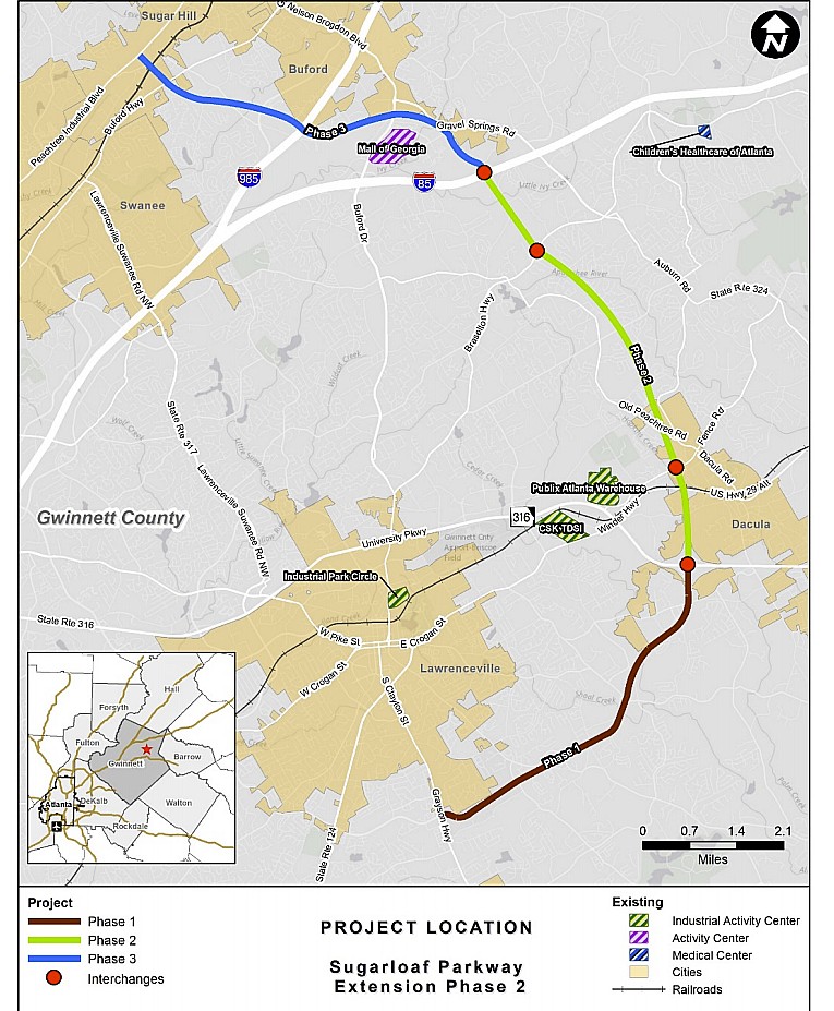
Then after the local four lane highway circles to I-85, there is to be one more phase of this road: Phrase 3, from I-85 back to Peachtree Industrial Boulevard, ending within the City of Sugar Hill south of the county’s E.E. Robinson Park.
Building four-lane roads today is costly. The extension from Georgia Highway 316 to I-85, currently known as phase 2, is anticipated to cost $305 million.
Phase 3 may not come until after 2030. Its route follow right-of-way that was previously known as Northern Arc, a now-dead four lane road that sought to connect I-85 with I-75. That route provided an alternate, especially for trucks, traveling from Northwest Georgia to I-85 and points northeastward.
Phase 3’s route, to be 5.8 miles, passes just north of the Mall of Georgia, abuts the rear of the Best Buy property line. You can see pine trees growing there now. On the other side of Georgia Highway 20, the road’s closest neighbor will be the Bank of the Ozarks.
The road passes over Plunkett Road and I-365. On Plunkett Road, it will bisect two subdivisions, Sage Stone and Westleigh. The route between the two subdivisions is clearly obvious by being undeveloped with tree overgrowth now. Years from now, it will be alive with the roar of vehicles clearly heard in these two areas, where houses are close to the right-of-way. I bet that many of this area’s current homeowners are not aware that a busy four-lane highway will be that close to the location some day.
By that time, the way our mobile society operates, many of the current homeowners may not be living in those houses, having moved away. Yet the area could suffer from highway noises. The value of the housing could possibly be negatively affected by the projected road.
Yet no matter where you live in Gwinnett, there may be noise problems from vehicular traffic. The very nature of Gwinnett’s growth insures this.
- Have a comment? Send to: elliott@brack.net
